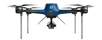
5G LiDAR Drone
Industrial Drones

Product Overview
The 5G LiDAR Drone (GA-IN-5G3D) from Garuda Aerospace is an aerial mapping platform designed for 3D terrain modelling and large-area geospatial data capture. Equipped with a LiDAR scanning system and 5G-enabled communication, the drone is designed to support long-range BVLOS missions up to 20 km, subject to applicable DGCA BVLOS approvals. The platform is designed to support mapping of infrastructure corridors, mining sites, and complex terrains, and to reduce the need for personnel in hazardous or difficult-to-access survey areas compared to conventional ground survey methods.
Technical Data
Model Name
GA-IN-5G3D
Rated Payload (kg)
4 kg
Gross Weight (kg)
12 kg
Rated Climb Rate
3-4 m/s
Rated Speed
10 m/s
Tested Endurance
40 mins
Rated Range
5 km
Design Altitude
4000 m
Dimensions
2030 x 1884 x 540 mm
Rated Ceiling
120 m
System Features
Equipped with LiDAR scanning capability intended to support 3D mapping applications
Offers BVLOS mission capability intended for large-area survey operations
Supports autonomous waypoint-based flight mission planning
Supports real-time terrain modelling and mapping functionality
Incorporates 5G-enabled communication designed to facilitate real-time data transmission
Designed to provide stable flight performance for scanning-based applications
Portable form factor designed for field deployment
Configured for industrial-scale mapping operations
Payload & Sensor System


RGB Camera
Provides aerial visual monitoring and situational awareness during flight.

Obstacle Sensors
Incorporates obstacle detection and avoidance to enhance operational safety.

GNSS Navigation System
Equipped with positioning capability for mapping missions.
Applications

Infrastructure and Corridor Mapping

Mining & Quarry Operations

Forestry & Environmental Monitoring

Urban Planning & Large-Area Survey
Garuda's Advantage
Optimised survey timelines with leaner field deployment
Digital terrain modelling to prescribed accuracy specifications
LiDAR-based mapping with high pointdensity data outputs
BVLOS-enabled UAV operations for extended-range surveys