
Spotlight | Jul 25, 2026 | 2 Min
Spotlight | Jul 25, 2026 | 2 Min
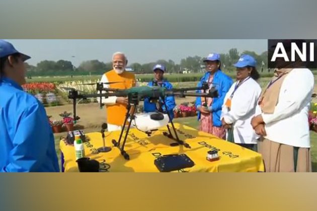
Prime Minister Narendra Modi on Monday handed over 1000 drones to 1,000 Namo Drone Didis across 10 locations across the country and disbursed bank loans to Self Help Groups (SHGs) in the Sashakt Nari - Viksit Bharat programme at Indian Agricultural Research Institute, Pusa in New Delhi.The PM also interacted with Lakhpati Didis while they shared their stories of resilience, determination and success.Speaking at Sashakt Nari - Viksit Bharat programme, the Prime Minister said, "Today's event is a historic one. In the coming years, drone technology is going to expand in the country. Innumerable avenues are going to open up for the 'Namo Drone Didis' in the country. In the last 10 years, the way Self Help Groups have expanded in the country is a matter of study. SHGs in India have created a new history in the area of women empowerment.""Drones will act as a capable channel/medium for delivery of small items like milk and groceries. Drones will also play a pivotal role in the delivery of medicines and medical samples. Namo drone didi Yojana is enabling women to become drone pilots, opening up countless opportunities for them," the PM added.Some of the drones distributed by the PM were Kisan drones manufactured by Garuda Aerospace."It is extremely validating to see our Honorable Prime Minister Narendra Modiji distributing 1000 drones to Drone Didis representing Women Self Help Groups from 22 states. Our goal is to ensure Women Entrepreneurs in rural India and Indian farmers have access to affordable Precision Agri Drone Technology and create massive employment for youth in our country" Agnishwar Jayaprakash, Founder and CEO of Garuda Aerospace said.The NaMo Drone Didi and Lakhpati Didi initiatives are an integral part of the Prime Minister's vision to promote economic empowerment and financial autonomy among women, especially in rural areas.During the programme, the Prime Minister felicitated Lakhpati Didis who have achieved success with the support of Deendayal Antyodaya Yojana - National Rural Livelihood Mission and are supporting and motivating other Self Help Group SHG members for their upliftment.The NaMo Drone Didi Initiative aims to empower rural women by training them to become drone pilots for agricultural purposes.The initiative aims to equip 15,000 women-led Self-Help Groups (SHGs) with agricultural drones to assist in tasks such as crop monitoring, spraying fertilisers and sowing seeds. (ANI)Source: https://www.bignewsnetwork.com/news/274152804/pm-modi-applauds-spirit-of-india-lakhpati-didis-distributed-1000-kisan-drones-to-1000-namo-drone-didis
Mar 25, 2025 | 2 min read
Drone manufacturer Garuda Aerospace, backed by Cricket legend Mahendra Singh Dhoni, has launched a border patrol surveillance drone, Trishul, the company said on Friday. The surveillance drone can be used for monitoring people movement, natural calamities and assessing traffic, among other things.Equipped with a variety of sensors including high-definition cameras, infra-red and radar, Trishul can provide data regarding speed and safety threats, Garuda Aerospace said in a release here."The launch of Trishul exemplifies our commitment to building a sustainable drone ecosystem, with products and services that set new benchmarks. Trishul makes way for uninterrupted access to critical real-time information and enables prompt decision-making," Garuda Aerospace Founder-CEO Agnishwar Jayaprakash said.Source: https://www.ndtvprofit.com/business/garuda-aerospace-unveils-border-patrol-surveillance-drone
Mar 25, 2025 | 2 min read

Filter By
Clear all
Category
View Less
Type
View Less
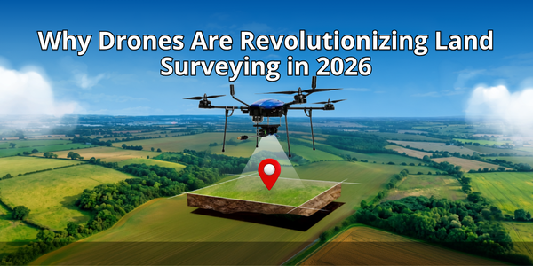
Drones in land surveying are transforming one of the most labour-intensive and time-consuming professional disciplines in India's infrastructure, construction, and agricultural sectors. What once required teams of surveyors spending days walking terrain with GPS receivers and total stations can now be accomplished by a single certified drone pilot in a few hours, with processed deliverables ready the same day. Academic studies confirm that UAV photogrammetry achieves centimetre-level accuracy when flights use RTK or PPK GNSS correction and well-distributed checkpoints, and field results consistently match this in real-world project environments. For India's rapidly expanding infrastructure pipeline and precision agriculture sector, the case for drone-based surveying has never been stronger.1. What Are Drones in Land Surveying and How Do They Work?Drones in land surveying are unmanned aerial vehicles equipped with high-resolution cameras, LiDAR scanners, multispectral sensors, and RTK/PPK GPS systems that capture geospatial data from above a survey area. Unlike ground-based surveying where data is collected point by point using total stations or GNSS receivers, drone surveys capture thousands of data points simultaneously in a single continuous flight pass.Core hardware on a survey-grade drone typically includes:High-resolution RGB cameras for photogrammetryLiDAR scanners for dense, vegetation-penetrating point cloudsMultispectral sensors for vegetation and soil analysisRTK/PPK GNSS systems for centimetre-level positional accuracyThe underlying technology is photogrammetry, a process where the drone captures hundreds of overlapping images from different angles, each tagged with precise coordinates from the onboard GNSS receiver. Photogrammetry software then stitches these images into georeferenced 2D orthomosaics and 3D point clouds, from which elevation models, contour lines, volumetric calculations, and cadastral maps are derived. Where higher accuracy or vegetation penetration is required, LiDAR sensors replace cameras, shooting millions of laser pulses that bounce off ground surfaces and return precise distance measurements regardless of plant cover above.2. Why Are Drones in Land Surveying Replacing Traditional Methods?Drones in land surveying are replacing traditional methods because they reduce field time by up to 45% and cut data collection costs by up to 50% compared to ground-based surveying. The operational advantages are compelling across every dimension of surveying practice.Comparison PointTraditional Ground SurveyDrone SurveyTeam size (50-hectare site)4–6 surveyors1 certified pilotTime to complete2–3 full daysUnder 3 hoursDeliverable turnaroundDays to weeksSame dayField time reductionBaselineUp to 45% lessData collection costBaselineUp to 50% lessAirport drainage case study (2,200 acres)Weeks of fieldwork1.5 cm horizontal / 2.5 cm vertical accuracy achieved rapidlyBeyond speed, drones provide access to terrain that is genuinely dangerous or impractical for ground-based teams.Active construction zones — surveyed without exposing crews to moving equipmentSteep slopes and unstable ground — mapped without risking falls or terrain hazardsPost-disaster areas — assessed without sending people into unsafe structuresDense vegetation — captured from above instead of requiring manual clearingThis safety benefit is increasingly valued by project owners who carry liability exposure for field team safety incidents.3. What Accuracy Can You Expect from Drones in Land Surveying?Drones in land surveying consistently achieve sub-5 cm accuracy with disciplined workflows, and centimetre-level precision with RTK or PPK GNSS correction.Survey Type / StudyHorizontal AccuracyVertical AccuracyNotesAcademic UAV photogrammetry benchmark~2–3 cm~3–6 cmWith RTK/PPK + well-placed ground control points1,000-acre pipeline monitoring survey2.3 cm—Field-documented result3,000-acre project1.5 cm (absolute)—Field-documented result20-hectare gravel pit stockpile study—0.24 m³ difference vs. terrestrial laser scannerField time cut from a full day to ~1 hourIt is important to understand that this accuracy is not automatic. It depends on:Flight altitudeImage overlapSensor qualityGNSS correction methodGround control point placementSurface conditionsDisciplined workflow and proper validation against independent checkpoints are what convert raw drone data into survey-grade deliverables that engineers and planners can rely on.4. The Step-by-Step Drone Land Survey WorkflowUnderstanding how drones in land surveying work in practice helps survey teams and clients know what to expect from a drone survey engagement.StepStageWhat Happens1Define the survey area and objectivesSet geographic extent, required accuracy, deliverable types (orthomosaic, DTM, DSM, point cloud, volumetric report), and intended downstream use2Plan the flight pathProgram altitude, 70–80% image overlap in both directions, geofencing around restricted airspace, and full-area coverage — executed autonomously3Place ground control points (GCPs)Distribute physical markers at known GPS coordinates; RTK-equipped drones need fewer GCPs due to real-time GNSS corrections4Execute the drone flight and capture dataAutonomous capture of overlapping images or LiDAR returns while the pilot monitors from the ground control station5Process the raw dataPhotogrammetry software (Pix4D, Agisoft Metashape, DJI Terra) builds orthomosaics, point clouds, and elevation models; LiDAR data processed on specialist platforms6Validate accuracy with checkpointsCompare drone-derived coordinates against ground-truth checkpoints to calculate RMSE and confirm accuracy requirements are met7Generate deliverables and integrate with workflowsExport orthomosaics, DTMs, DSMs, point clouds, contour maps, and volumetric reports in CAD/GIS/BIM-compatible formats5. The 5 Key Applications of Drones in Land Surveying5.1. Topographic Surveys for Construction and InfrastructureTopographic surveys are the most common application of drones in land surveying for India's construction and infrastructure sectors. Pre-construction DTMs and DSMs that would previously take survey teams a week to produce are now completed in hours, fed directly into civil engineering design software for cut-and-fill calculations, drainage planning, and foundation design.India's National Infrastructure Pipeline projects over Rs 111 lakh crore of infrastructure investmentThis is generating enormous demand for fast, accurate topographic survey data across road, rail, urban, and industrial projectsDrone surveys reduce the cost of topographic data collection by 40 to 60% while delivering equal or superior accuracyThe same mapping discipline underlying soil mapping and nutrient analysis in precision agriculture applies directly to engineering topographic workflows5.2. Cadastral Surveying and Land RecordsCadastral surveying — the mapping of property boundaries and land ownership records — is one of the most socially impactful applications of drones in land surveying in India. The government's SVAMITVA scheme has already completed cadastral drone surveys across 3.29 lakh villages, creating property records for rural communities for the first time in India's history.Produce 1:500 scale outputs meeting centimetre-level accuracy requirementsReduce data collection and processing time by up to 10 times compared to traditional methodsEnable small teams to cover large areas using a single remote controller managing multiple drones simultaneouslyDeliverables include digital orthomosaic maps, digital surface models, and 3D reality models that are far more visually useful for stakeholders than traditional vector maps alone5.3. Mining and Quarry Volumetric SurveysMining operations rely on frequent, accurate volumetric surveys of stockpiles, pit progress, and waste dumps for inventory management, financial reporting, and environmental compliance. Traditional ground-based stockpile measurement is slow, hazardous for surveyors working around active mining equipment, and infrequent enough that significant inventory discrepancies can accumulate between surveys.Drone surveys of mining sites produce 3D stockpile models with documented volumetric accuracy that compares directly with terrestrial laser scanner measurements, while reducing survey time from a full working day to approximately one hour. The ability to repeat surveys frequently at low marginal cost transforms inventory tracking from a periodic exercise into a near-real-time management tool.5.4. Agricultural Land MappingAgricultural land mapping is an application of drones in land surveying that directly supports precision agriculture services across India's farming regions. Drone-generated elevation models reveal drainage patterns, identify waterlogging zones, and map soil variability across farm plots, providing the spatial foundation for variable-rate input management programmes.When combined with crop health monitoring using multispectral sensors, drone land surveys provide farmers with a comprehensive spatial understanding of their fields that supports smarter decisions about irrigation, fertiliser placement, and crop rotation. In India's fragmented farming landscape where 89.4% of farms are under two hectares, drone surveys that can rapidly and affordably map small, irregular plots are particularly valuable.5.5. Disaster Assessment and Environmental MonitoringPost-disaster damage assessment is a time-critical application where drones in land surveying deliver outcomes that no other method can match for speed. After floods, earthquakes, or landslides, drone surveys produce accurate aerial maps of affected areas within hours, providing disaster response teams with the geospatial intelligence needed to plan rescue operations, assess infrastructure damage, and prioritise relief logistics.Forest canopy mappingCoastal erosion trackingFlood plain analysisAll of these benefit from the same combination of speed, spatial resolution, and repeat survey capability that makes drones valuable in engineering survey contexts. For organisations involved in seed spreading and reforestation programmes, drone surveys provide the pre-planting terrain analysis and post-planting progress monitoring that maximises reforestation success rates.6. What Sensors and Platforms Are Used for Drone Land Surveying?Sensor TypeBest Used ForKey CharacteristicsRGB Cameras with RTK GPSMost commercial topographic, cadastral, and construction surveysCost-effective, straightforward to process, centimetre-level accuracy with RTK GPS; modern platforms use mechanical shutters to eliminate blurLiDAR ScannersEngineering-grade infrastructure survey, forestry, vegetation-covered terrainHighest accuracy, penetrates vegetation canopy, directly measures 3D coordinates rather than deriving them, produces very high point densityMultispectral SensorsAgricultural and environmental monitoringCaptures near-infrared and other wavelengths beyond human vision to reveal vegetation health, soil moisture, and land cover; bridges land survey with precision agriculture drone services7. What Regulations Apply to Drones in Land Surveying in India?Commercial drone land surveying in India is regulated by the DGCA under the Drone Rules 2021.All drones above 250 grams used for commercial survey operations must be registered with a Unique Identification Number on the Digital Sky PlatformOperating pilots must hold a valid Remote Pilot Certificate obtained from a DGCA-approved training programmeSurvey operations near airports, military facilities, or international borders require additional airspace permissions from relevant ATC authorities through the Digital Sky PlatformCadastral surveys conducted in support of government land record programmes may require additional coordination with state revenue authoritiesSurvey companies and DaaS providers should verify full compliance status before mobilising to site on any commercial projectFinal ThoughtsDrones in land surveying have moved from an emerging technology to a commercially proven, operationally standard tool across construction, infrastructure, mining, agriculture, and disaster management in India. The combination of centimetre-level accuracy, dramatically reduced field time, improved safety, and rich multi-purpose data output makes drone surveys the rational choice for the vast majority of survey applications that do not require boundary peg-level control network precision.Whether you are a construction project manager looking to improve survey efficiency, an agricultural operator seeking spatial data to underpin precision farming decisions, or a survey professional looking to build drone capability through a DGCA-certified training programme, the tools and regulatory framework to make drone surveying work for you are fully in place in India in 2026.
Jul 25, 2026 | 2 min read
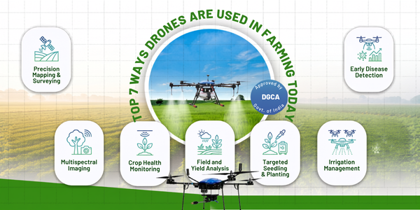
Drones in farming are rapidly becoming as fundamental to modern agriculture as tractors and irrigation systems. What began as an experimental technology a decade ago is now a commercially deployed, government-backed reality across India's farming regions from paddy fields in Telangana to wheat belts in Punjab and cotton farms in Maharashtra. The Indian agriculture drone market is projected to grow from USD 302.3 million in 2025 to USD 2,185.5 million by 2034, reflecting not just investor optimism but genuine adoption at the farm level. This guide covers the 7 most important ways drones are being used in farming today, with practical details on how each application works, what it costs, and what results it delivers.1. Why Are Drones in Farming Growing So Rapidly in India?Drones in farming are growing rapidly in India because they directly address the country's most persistent agricultural challenges. India's farming landscape is characterised by small, fragmented holdings -- 89.4% of farms are under two hectares -- where large ground-based machinery is impractical, labour during peak seasons is increasingly scarce, and input costs are under constant pressure.Drones navigate small and irregularly shaped plots with ease, complete spraying or monitoring work in a fraction of the time required by manual methods, and deliver data-driven precision that reduces waste across water, fertiliser, and pesticide usage. For a sector where profit margins are already tight, the combination of cost reduction and yield improvement that drones deliver is compelling enough to drive adoption even among farmers with limited technology experience. Government initiatives like NAMO Drone Didi -- which aims to deploy drones to 15,000 women-led Self Help Groups -- are further accelerating grassroots adoption across rural India.2. The Top 7 Ways Drones Are Used in Farming2.1. Precision Crop SprayingPrecision crop spraying is the single most widely deployed application of drones in farming across India. Instead of manual backpack sprayers that expose farmworkers to toxic chemicals and deliver uneven coverage, drones apply pesticides, herbicides, and foliar fertilisers from above with GPS-guided precision and consistent droplet distribution.Drone spraying technology uses terrain-following sensors to maintain a precise altitude above the crop canopy regardless of field undulation, and specialised nozzles that produce fine droplets designed to adhere to leaf surfaces for maximum efficacy. The results are measurable: precision spraying drones reduce water consumption by up to 90% and pesticide application by up to 30% compared to conventional ground-based methods, while covering 15 to 20 hectares per hour -- approximately 40 times faster than a manual backpack sprayer.Beyond efficiency, drone spraying completely eliminates farmworker exposure to toxic agrochemicals, addressing a serious occupational health risk that affects millions of Indian agricultural workers every season.2.2. Crop Health Monitoring Using NDVI and Multispectral ImagingCrop health monitoring is the most data-rich application of drones in farming, enabling farmers to see what the human eye cannot detect. Drones equipped with multispectral sensors capture how plants reflect different wavelengths of light, including near-infrared channels that respond to chlorophyll content and plant water status.This data is processed into Normalised Difference Vegetation Index (NDVI) maps that reveal the health status of every square metre of a field in a single flight pass. Areas of water stress, nutrient deficiency, pest pressure, or early disease infection show up as distinct colour zones on the health map, enabling farmers to target interventions precisely rather than applying treatments across the entire field. Crop health monitoring using drone imagery is capable of millimetre-level location accuracy far superior to satellite imagery, which offers metre-level accuracy and is frequently obstructed by cloud cover.Using precision farming systems that incorporate drone health monitoring data has been shown to increase yields by as much as 5%, a significant improvement in an industry where margins are persistently tight.2.3. Soil Mapping and Field AnalysisSoil mapping using drones gives farmers a detailed, spatially accurate understanding of the variability across their fields before planting begins. Drones equipped with multispectral and RGB cameras, combined with elevation modelling, generate 3D field maps that reveal soil composition variation, drainage patterns, low-lying waterlogging zones, and high-elevation dry spots.This spatial understanding is the foundation of precision input management. Rather than applying a uniform dose of fertiliser across the entire field, farmers who have soil mapping and nutrient analysis data can generate variable-rate prescription maps that direct exactly the right nutrient combination to each zone of the field. The result is higher yield uniformity, lower fertiliser expenditure, and better long-term soil health all from a pre-season drone survey that takes a fraction of the time and cost of traditional physical soil sampling programmes.Some advanced drone sensor configurations also enable nitrogen level monitoring in soil directly, supporting precise fertiliser planning without the laboratory processing delay of conventional sampling.2.4. Disease and Pest DetectionEarly disease and pest detection is one of the highest-value applications of drones in farming because the economic damage of late detection is enormous. By the time a disease or pest infestation is visible to a farmer walking their field, it has typically already spread far beyond the area where it was first present.Drones equipped with multispectral and high-resolution RGB cameras can identify the earliest spectral signatures of fungal infection, bacterial disease, and pest damage weeks before visible symptoms appear. Disease and pest detection using AI-powered analysis of drone imagery can pinpoint infection zones to within a few metres, enabling targeted treatment of affected patches rather than prophylactic whole-field chemical applications that increase cost and environmental impact.A practical example illustrates the value: a farmer who spots a pest outbreak in a small corner of a 20-hectare field through a drone health scan can treat only that affected patch, spending a fraction of what whole-field treatment would cost, while preventing the outbreak from spreading to the rest of the crop.2.5. Seed Spreading and Aerial SeedingSeed spreading using drones is an emerging but rapidly growing application of drones in farming, particularly for direct seeding of paddy fields, cover crop establishment, and reforestation projects. Drone seeders shoot seed pods or coated seeds into soil at controlled depth and spacing, covering large areas quickly with minimal soil disturbance.Seed spreading drones are particularly valuable for fields that are too wet, steep, or remote for conventional planting equipment to access safely. In flooded paddy conditions where transplanting is physically demanding and labour-intensive, aerial seeding drones enable direct seeding without the waterlogged field conditions that make manual transplanting hazardous. In reforestation contexts, a coordinated fleet of ten drones with two operators can plant up to 400,000 trees per day a scale that would take a manual planting crew weeks to match.2.6. Irrigation Monitoring and Water ManagementIrrigation monitoring is a critical application of drones in farming in a country where agriculture consumes approximately 80% of India's freshwater and irrigation efficiency remains low across large parts of the country. Drones equipped with thermal infrared cameras detect soil moisture levels and plant water stress with spatial precision that ground-based sensors cannot match at field scale.Thermal drone imagery reveals exactly which sections of a field are receiving adequate irrigation, which are under-watered and showing heat stress, and which are over-watered and at risk of waterlogging or disease. This spatial map of moisture distribution enables farmers to calibrate irrigation system output across different field zones, reducing overall water consumption while improving crop uniformity.The same thermal cameras can detect leaks in buried irrigation pipes by identifying abnormal temperature zones at the soil surface above the leak location enabling targeted repair rather than systematic excavation of the entire irrigation network.2.7. Livestock and Farm Asset MonitoringLivestock and farm asset monitoring is a time-saving application of drones in farming that is particularly valuable on larger farms or stations where animals and equipment are distributed across extensive areas. A single drone operator can survey thousands of acres in the time it would take a farmhand to drive a fraction of that distance, locating missing animals, checking fencing integrity, monitoring water trough levels, and assessing pasture condition from above.Thermal sensor drones are especially useful for livestock monitoring, detecting the heat signatures of individual animals in dense vegetation, tall grass, or at night. This capability supports early identification of animals in distress, calving incidents, or animals separated from the herd following storms or mustering. Pollination assistance drones extend this monitoring principle to high-value orchard crops, where drone-assisted pollen distribution and canopy health assessment support premium crop management programmes that larger operations increasingly deploy.3. What Are the Measurable Benefits of Drones in Farming?3.1. Cost ReductionDrones in farming reduce input costs across every major agrochemical category. Precision spraying reduces pesticide usage by up to 30%, reducing direct chemical expenditure while also lowering environmental contamination costs. Soil mapping-driven variable-rate fertiliser programmes eliminate the over-application that typically accounts for 20 to 40% of fertiliser expenditure on farms without precision management.A study of corn, soybean, and wheat farming estimated that drone adoption could save farmers an estimated USD 1.3 billion annually through improved yields and reduced input costs. For Indian smallholders operating on tight margins, even a 10 to 15% reduction in input costs represents a meaningful improvement in farm profitability.3.2. Yield ImprovementPrecision farming systems that incorporate drone health monitoring data consistently demonstrate yield improvements of 3 to 8% compared to conventional management, primarily through earlier problem detection, more precise input placement, and better irrigation management. Over a growing season, these improvements translate directly into additional income per hectare that compounds across a farm's total cropping area.3.3. Labour SavingA drone can complete spraying, monitoring, or seeding work that would require a team of farm labourers for days in a matter of hours. During peak agricultural seasons when labour availability is most constrained and labour costs are highest, this speed advantage is operationally critical. For farmers facing growing rural labour shortages as workers migrate to urban areas, drones provide an increasingly important path to maintaining operational capacity without proportional labour cost increases.3.4. Farmer SafetyEliminating direct farmworker exposure to pesticides and herbicides is one of the most significant and underappreciated benefits of drones in farming. The World Health Organization has documented that agricultural workers who apply pesticides face the greatest health risks from direct chemical exposure. Drone spraying removes this risk entirely, with the operator managing the entire process from a safe distance using a remote controller.4. How to Access Drone Farming Services in India4.1. Drone-as-a-Service ModelThe most accessible pathway for most Indian farmers is the Drone-as-a-Service (DaaS) model, where farmers pay per acre for professional drone operations delivered by a certified operator with all necessary equipment. This model eliminates the capital investment, training requirement, and maintenance burden of drone ownership, making the technology accessible to smallholders who could not justify purchasing a drone outright.Under the DaaS model, farmers book a service, a certified pilot arrives with the appropriate drone and payload, completes the operation, and provides the farmer with processed data or field reports. Explore the full range of precision agriculture drone services available in India to understand what service models are accessible for your specific farm operation and crop type.4.2. In-House Drone CapabilityFor larger farming operations, cooperatives, or Farmer Producer Organisations (FPOs) with sufficient cropping area to justify the capital expenditure, building in-house drone capability through equipment purchase and pilot certification is a viable option. This pathway requires investment in drone hardware, a DGCA-approved pilot training programme to obtain a Remote Pilot Certificate, and photogrammetry or farm management software to process and act on the data collected.In-house capability delivers the greatest operational flexibility and lowest per-operation cost over time, particularly for farms with year-round cropping programmes that generate sufficient survey and spraying volume to justify the investment.5. What Regulations Apply to Drones in Farming in India?Drones used commercially for farming in India are regulated by the DGCA under the Drone Rules 2021. Operating a drone for agricultural spraying or monitoring requires a valid Remote Pilot Certificate obtained from a DGCA-approved Remote Pilot Training Organisation, a Unique Identification Number registered on the Digital Sky Platform, and compliance with airspace zone restrictions that govern where and at what altitude drones can fly.Additional compliance requirements for agricultural spraying include adherence to Central Insecticides Board and Registration Committee (CIB&RC) guidelines on approved chemicals, buffer zones around water bodies, and dosage rate limits. When hiring a DaaS provider, always verify that the operator is DGCA-certified and compliant with all applicable regulations before authorising operations on your land.Final ThoughtsDrones in farming are not a future technology -- they are a present commercial reality delivering measurable yield improvements, cost reductions, and safety benefits to Indian farmers right now. Whether you are a smallholder exploring the DaaS model for crop spraying, a larger operator considering in-house drone capability for comprehensive precision agriculture, or an agri-entrepreneur building a drone service business to serve your farming community, the tools, the regulatory framework, and the service ecosystem are all in place.The combination of government support through programmes like NAMO Drone Didi, a growing network of DGCA-certified drone pilots, and increasingly affordable drone hardware means that precision aerial intelligence is becoming accessible to every segment of Indian agriculture not just large commercial operations.
Jul 25, 2026 | 2 min read
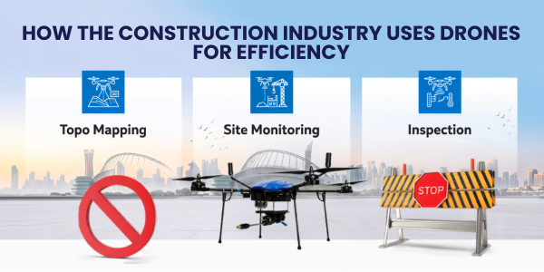
skyline of India is changing at an unprecedented pace, with highways stretching farther, smart cities taking shape, metro networks expanding, and massive infrastructure projects redefining the nation's future. Behind this transformation, drones in construction have emerged as a game-changing technology that is revolutionizing how projects are planned, built, and managed. What was once a process dependent on manual surveys, lengthy inspections, and time-consuming progress checks is now powered by aerial intelligence that delivers accurate, real-time insights within minutes1. Why Are Drones in Construction Becoming Standard Practice?Drones in construction are becoming standard practice because they deliver survey-grade geospatial data at a fraction of the cost and time of traditional ground survey methods. A conventional topographic survey of a 50-hectare construction site might require a survey team of 4 to 6 people working for 2 to 3 days. A drone survey of the same site can be completed by a single certified pilot in under 3 hours, with processed deliverables ready within the same day.The cost savings are equally significant. DaaS providers consistently report that drone surveys deliver 40 to 60% cost reductions compared to traditional survey methods, while producing higher-resolution data across a wider variety of output formats. For large infrastructure projects with extensive survey requirements, this savings compounds significantly across the project lifecycle.Beyond cost and speed, drones provide access. Construction sites involve dangerous working conditions, difficult terrain, and structures at height that are genuinely hazardous for human inspectors to access directly. Drones eliminate the safety risk while delivering more detailed data than a human inspector carrying a clipboard could practically collect in the same timeframe.2. The 8 Key Applications of Drones in Construction2.1. Pre-Construction Topographic SurveysPre-construction topographic surveys are the most fundamental application of drones in construction. Before any earthmoving begins, project teams need accurate elevation models, drainage analysis, and spatial understanding of the site. Drone surveys using RGB cameras and RTK GPS produce centimetre-accurate digital terrain models (DTMs) and digital surface models (DSMs) that replace conventional total station and level surveys for most commercial applications.These models feed directly into civil engineering design software, enabling cut-and-fill calculations, drainage planning, and foundation design that are grounded in accurate real-world data rather than less frequent or less detailed ground measurements. For projects on uneven terrain, accurate pre-construction DTMs can prevent costly design errors that only become apparent during earthwork execution.2.2. Earthwork Volume CalculationsCalculating the volume of earth moved, stockpiled, or remaining in a cut or fill section is one of the most practically valuable applications of drones in construction. LiDAR and photogrammetry-equipped drones generate precise volumetric models of stockpiles and earthwork areas by comparing current surface models against design reference surfaces.Where traditional volumetric surveys using total stations might be conducted monthly because of the labour involved, drone volumetric surveys can be repeated weekly or even more frequently at minimal marginal cost. This frequency enables construction project managers to track earthwork progress against programme milestones in near-real-time, identifying problems while there is still time to recover them.2.3. Construction Progress MonitoringConstruction progress monitoring is one of the most widely adopted drone applications across Indian construction sites. Regular drone flights over an active construction site produce consistent, georeferenced aerial imagery that documents exactly what has been built, where, and when. This documentation supports programme management, client reporting, dispute resolution, and quality assurance across the project lifecycle.Progress imagery captured by drones provides a far more comprehensive and objective record than site photography or progress reports prepared by on-site staff. Time-lapse sequences built from regular drone flights are also increasingly used as marketing and stakeholder communication tools for major projects, creating compelling visual evidence of project advancement.2.4. 3D Modelling and BIM IntegrationDrone-generated 3D models are increasingly being integrated directly into Building Information Modelling (BIM) workflows used for construction project planning and management. Photogrammetry processing converts drone mapping imagery into accurate, georeferenced 3D point clouds and mesh models that can be overlaid against BIM design models.This clash detection capability is particularly valuable in complex infrastructure projects where multiple construction activities are happening simultaneously across a large site. Identifying a structural element built in the wrong position during construction rather than during a post-construction inspection can save significant rework costs and programme delay.2.5. Safety Inspections and Hazard IdentificationSafety inspections are a critical and growing application of drones in construction. Inspecting scaffolding, formwork, temporary works, and structures at height exposes site safety officers to the same hazards they are assessing. Drone inspections of these elements deliver visual data from positions and angles that would be dangerous or impractical for human inspectors to access.Beyond routine inspection, drones are used to assess site hazards after weather events, monitor slope stability in excavations and embankments, and document near-miss incidents. The photographic and video record generated by drone inspections is increasingly used in safety management documentation, regulatory compliance, and insurance claim support.2.6. Thermal Inspections of StructuresThermal sensor-equipped drones identify heat anomalies in completed structures that indicate insulation defects, moisture ingress, concrete delamination, or electrical installation problems. This application is most valuable during final quality inspections of buildings, roofing systems, and facades, where thermal differentials reveal defects that are invisible to standard cameras.Thermal drone inspections of building envelopes before handover are becoming standard practice on commercial and premium residential developments in India, providing developers with documented evidence of quality that supports warranty claims and distinguishes their product in a competitive market.2.7. Asset and Equipment TrackingLarge construction sites involve significant numbers of mobile assets including plant, equipment, materials, and vehicles that need to be tracked for operational efficiency and security. Regular drone flights over a construction site provide a comprehensive overhead view that identifies asset locations, equipment utilisation patterns, and potential security vulnerabilities.This application is particularly valuable for large linear infrastructure projects such as roads, railways, and pipelines, where assets are dispersed across kilometres of active construction corridor and site management would otherwise require extensive travel to maintain operational oversight.2.8. Documentation for Dispute Resolution and Legal ComplianceConstruction disputes frequently turn on factual questions about what was built, when, and in what condition. Timestamped, georeferenced drone imagery provides objective, comprehensive site documentation that has become increasingly important in contract dispute resolution, insurance claim assessment, and regulatory compliance reporting.Many Indian infrastructure developers and contractors are now conducting regular drone surveys not just for operational benefit but as a standard risk management measure, ensuring that a comprehensive visual record of site conditions exists for every significant phase of construction.3. What Drones and Sensors Are Used in Construction?3.1. Multirotor DronesMultirotor drones, particularly hexacopters and octocopters, are the primary platform for construction drone applications. Their ability to hover precisely, manoeuvre in confined spaces, and operate safely near structures makes them the most versatile choice for the range of tasks construction sites require. Most commercial construction drone operations use multirotor platforms capable of carrying RGB cameras, multispectral sensors, thermal payloads, or LiDAR scanners depending on the specific application.3.2. Fixed-Wing Drones and VTOL PlatformsFor large-area surveys covering hundreds of hectares, fixed-wing drones and VTOL (Vertical Takeoff and Landing) hybrid platforms offer greater efficiency than multirotors due to their longer flight times and faster coverage speeds. India's major linear infrastructure projects, including highway and railway corridors, routinely use fixed-wing or VTOL platforms for corridor surveys that span tens or hundreds of kilometres.3.3. RGB Cameras for Progress MonitoringHigh-resolution RGB cameras are the primary sensor for progress documentation, 3D modelling, and general site survey. Cameras with RTK GPS integration produce survey-grade orthomosaic maps and 3D point clouds that can be compared directly against BIM models and design drawings. The same technology used for drone mapping and survey work in agricultural contexts applies directly to construction site documentation.3.4. LiDAR for Precision Terrain ModellingLiDAR-equipped drones are used where centimetre-accuracy terrain data is required across complex or vegetated terrain. LiDAR penetrates vegetation canopy to map actual ground surfaces and produces denser, more accurate point clouds than photogrammetry in environments where shadow or texture variation limits image-based reconstruction.3.5. Thermal Cameras for Quality InspectionsThermal imaging cameras mounted on drones identify temperature anomalies that indicate structural defects, moisture problems, and insulation failures in completed construction elements. The same thermal drone platforms used for disease and pest detection in agriculture apply directly to construction quality inspection.4. How to Integrate Drones in Construction Projects: Step-by-StepSuccessful integration of drones in construction requires a structured approach that aligns drone operations with project management workflows.Step 1 -- Define survey requirements by project phase. Pre-construction surveys require topographic DTMs and site boundary mapping. Construction phase surveys require progress documentation and volumetric tracking. Post-construction surveys require as-built documentation and quality inspection. Map specific deliverables to each phase before selecting platforms or providers.Step 2 -- Select the right drone platform and sensor combination. Match platform and sensor selection to application requirements. RGB cameras with RTK GPS for progress monitoring and 3D modelling. LiDAR for precision terrain surveys. Thermal cameras for quality inspections. Consider whether a drone-as-a-service model or in-house capability is more appropriate for your project volume and duration.Step 3 -- Ensure DGCA compliance. All commercial drone operations in India require DGCA-approved operators holding valid Remote Pilot Certificates and drones registered with Unique Identification Numbers. Construction sites near airports or in yellow airspace zones require additional ATC permission through the Digital Sky Platform. Confirm compliance status before any drone mobilisation to site.Step 4 -- Establish ground control points for survey-grade accuracy. For construction survey applications where data will feed into design software or BIM models, place surveyed ground control points (GCPs) across the site before each drone flight. GCPs dramatically improve the absolute accuracy of photogrammetric models and ensure data is spatially aligned with existing project coordinate systems.Step 5 -- Integrate drone data into project management workflows. Drone survey data is only as valuable as its integration into the decision-making processes that drive construction. Connect orthomosaic maps and progress reports directly to project management platforms, BIM systems, and client reporting frameworks. Establish a consistent survey schedule so that data is available at the frequency the project actually needs.Step 6 -- Train site staff to interpret and use drone outputs. Project managers, site engineers, and quantity surveyors who understand how to read and work with drone survey outputs get significantly more value from the technology than teams who receive data but are not trained to apply it. Brief all relevant stakeholders on the capabilities, limitations, and interpretation of drone deliverables at project inception.5. What Do Drones in Construction Cost in India?Drone survey costs in India depend on site area, frequency, deliverable type, and whether you use an in-house drone operator or a drone-as-a-service provider. For small to medium construction sites between 5 and 50 hectares, a single drone survey including data processing typically costs between Rs 20,000 and Rs 80,000 depending on deliverable complexity. For large infrastructure projects, volume-based pricing and survey programme agreements are common.In-house drone capability requires investment in a certified pilot through a DGCA-approved training programme, survey-grade drone hardware ranging from Rs 3,00,000 to Rs 10,00,000 depending on sensor configuration, and photogrammetry software licences. For projects with regular ongoing survey requirements, in-house capability typically achieves a positive return within 12 to 18 months of deployment.6. The Future of Drones in ConstructionThe future of drones in construction is defined by greater automation, tighter BIM integration, and the emergence of AI-driven site monitoring platforms. Real-time drone data feeds directly into digital twin models of active construction sites, enabling project managers to monitor progress against programme on a continuous basis rather than at periodic survey intervals.Autonomous drone-in-a-box systems that launch, fly, and return without pilot intervention are already being piloted on major construction projects globally and are entering commercial availability in India. These systems enable daily or even hourly automated progress surveys at minimal operational overhead, transforming the frequency and completeness of construction documentation.The same precision, autonomy, and data quality improvements driving construction drone adoption are also advancing precision agriculture and crop health monitoring applications, reflecting how broadly drone technology innovation across sectors is accelerating simultaneously.Final ThoughtsDrones in construction are no longer an emerging technology experiment -- they are a proven, commercially deployed capability delivering measurable cost, time, and safety improvements on projects across India. The construction companies and project developers who build drone survey capability into their standard workflows today will carry a significant competitive advantage as project delivery pressures continue to intensify across India's infrastructure development pipeline.Whether you are a construction professional exploring how to integrate drones into your next project, or a drone operator looking to build a client base in the construction sector, the foundational step is the same: understand the applications, ensure regulatory compliance through a DGCA-certified training programme, and position drone data as a core input into project management decision-making.Explore how drone-as-a-service solutions and DGCA-certified pilot training are supporting construction projects and infrastructure development across India.
Jul 15, 2026 | 2 min read
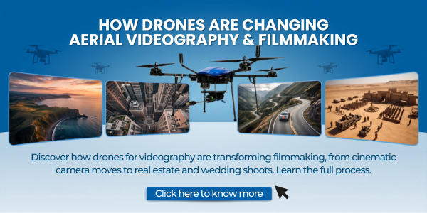
1. What Are Drones for Videography and Why Do They Matter?Drones for videography are unmanned aerial vehicles fitted with stabilized cameras, used specifically to capture moving footage rather than still photographs. Unlike a photography drone that prioritizes single-frame sharpness, a videography drone is built around smooth motion, consistent exposure across a shot, and a gimbal that can hold a frame steady while the aircraft banks, climbs, or tracks a subject.They matter because video is judged differently from photography. A single soft frame in a photo series barely registers. A single jittery second in a video is obvious to every viewer. That is why the gimbal, the flight controller, and the transmission system matter as much as the sensor itself when a drone is being used for video work.2. How Aerial Videography Changed FilmmakingAerial videography did not just add a new camera angle. It changed the grammar of how scenes are shot and edited together.2.1 Camera Movements That Were Once ImpossibleBefore drones, a rising crane shot or a long tracking shot over a landscape required a helicopter, a technocrane, or a cable rig. All three came with high costs, weather restrictions, and long setup times. A drone compresses that entire process into a battery cycle and a pre-planned flight path.2.2 Faster Production TimelinesA two-person drone crew can now capture establishing shots, transitions, and reveal shots in a fraction of the time a full aerial unit used to need. This has pushed aerial footage out of big-budget productions and into everyday work like weddings, corporate videos, and short-form social content.2.3 New Visual Language in StorytellingDirectors now plan for drone reveals the same way they plan for a dolly-in or a close-up. The slow pull-back that reveals scale, or the fast FPV dive through a gap, has become its own recognizable shot type rather than a novelty.Related Reads: The Rise of Drone Shows: A New Era of Entertainment3. Step-by-Step: How Drones Actually Improve a ShootUnderstanding the direct impact is easier when you follow the workflow a videographer goes through on location.Step 1: Scouting the location from the air. Before committing to a shot list, pilots often send the drone up for a quick recon flight. This reveals sightlines, obstacles, and lighting conditions from a perspective a ground scout cannot get.Step 2: Planning the flight path. Many aerial platforms now support waypoint mapping, letting a pilot pre-program a smooth, repeatable path. This is especially useful for real estate, construction documentation, and any shoot that needs the exact same shot across multiple sessions.Step 3: Capturing the primary footage. With stabilization handling the physical smoothing, the pilot focuses on framing, subject tracking, and exposure. Intelligent tracking modes can follow a moving subject like a car or a runner while the pilot manages altitude and angle.Step 4: Reviewing footage on-site. Live transmission to a monitor or controller means a director can approve or reshoot a take immediately, rather than discovering a problem days later in the edit bay.Step 5: Handing off for post-production. RAW or high-bitrate footage is transferred and color-graded alongside ground footage, matched for tone and exposure so the aerial shots blend naturally into the final cut.4. Key Equipment Considerations for Drone VideographyNot every drone is built for the same kind of shoot, and matching the aircraft to the job matters more than chasing the highest spec sheet.4.1 Sensor Size and Low-Light PerformanceA larger image sensor holds more detail in shadows and handles dusk or indoor-adjacent lighting far better than a small sensor. For videographers shooting golden hour weddings or evening events, this is often the deciding factor between usable and unusable footage.4.2 Stabilization and Gimbal QualityA three-axis gimbal is now close to standard on serious videography drones. It is the single biggest factor separating cinematic footage from footage that looks like it was shot on a shaking pole.4.3 Flight Time and Battery ManagementLonger flight time means fewer interruptions mid-shoot and more usable takes per battery cycle. On a paid shoot, swapping batteries every ten minutes can break the creative momentum of a session, so total airtime is a practical production concern, not just a spec sheet number.4.4 Transmission Range and Signal ReliabilityA stable, long-range signal keeps the live feed usable even when the aircraft is shooting a wide establishing shot far from the operator. This is particularly important on large properties, industrial sites, or open landscapes.5. How to Get Started With Aerial VideographyStep 1: Learn the regulations in your country. Most regions require registration for drones above a certain weight, and commercial use almost always requires some form of licensing. Getting proper drone pilot training early avoids costly mistakes and keeps every shoot on the right side of the law.Step 2: Choose a drone that matches your genre. A lightweight aircraft suits travel and social content, while a larger platform with a bigger sensor suits commercial and cinematic work. Reviewing the available range of drone products is a useful first step before committing to a purchase.Step 3: Practice manual flight before relying on automation. Intelligent modes are helpful, but understanding manual control builds the instinct needed to react when automation fails or conditions change mid-flight.Step 4: Get certified if you plan to shoot commercially. A certified drone pilot qualification is often required for paid work, insurance coverage, and access to restricted airspace permissions.Step 5: Build a small but reliable kit. Extra batteries, ND filters, spare propellers, and a rugged case matter more than a second aircraft when you are starting out.6. Where Aerial Videography Is Used TodayAerial footage has spread well beyond film sets into everyday commercial work.Weddings and events: Sweeping shots of venues and guest arrivals that were once impossible on a normal budget.Real estate: Full-property flythroughs that give buyers a sense of scale and layout no ground photo can match.Construction and infrastructure: Progress documentation captured through recurring drone-as-a-service engagements rather than one-off shoots.Travel and tourism content: Landscape reveals that anchor a video and set the tone before any ground footage appears.Industrial monitoring paired with video: Sites that already use industrial drones for inspection often repurpose the same flights for promotional or documentation footage.7. What Comes Next for Drone VideographyTwo developments are shaping the next few years of aerial video work. First, obstacle avoidance and AI tracking are getting reliable enough that a single pilot can safely fly complex shots that once required a second operator watching for hazards. Second, video quality is closing the gap with dedicated cinema cameras, with larger sensors and better color science appearing on smaller, lighter aircraft each year.For anyone serious about the craft, the practical path forward is the same one that has always worked: learn the rules, train properly, and fly with intent rather than relying on the aircraft to do the storytelling for you.8. Frequently Asked Questions01 Do I need a license to shoot video with a drone commercially? In most countries, yes. Paid aerial video work typically requires drone registration and a pilot certification, so check local aviation authority rules before accepting client work.02 What makes a drone good for video instead of just photos? A stable three-axis gimbal, consistent exposure control during movement, and reliable video codecs matter more for video work than raw megapixel count, which is the priority for still photography.03 Can beginners shoot professional-looking aerial video? Yes, with practice. Learning manual flight first, understanding basic cinematography principles, and completing structured drone pilot training closes most of the gap between hobbyist and professional results.
Jul 15, 2026 | 2 min read

Drone professions are among the fastest-growing career tracks in the world right now, and the window to enter this industry at an early stage is still wide open. From agriculture and construction to cinema and emergency response, trained drone pilots and drone technologists are in high demand across dozens of industries. India alone is witnessing a surge in government-backed drone adoption, DGCA-certified pilot programs, and private sector investment that is creating thousands of new roles every year. If you have been wondering whether a career in drones is worth pursuing, the answer is a clear yes, and this guide will show you exactly where to begin.1. What Makes Drone Professions One of the Fastest-Growing Career Fields?Drone professions are growing because industries across the board are replacing slow, expensive, and risky manual processes with fast, affordable, and precise drone-based solutions. The numbers back this up: the global commercial drone market is projected to reach over $54 billion by 2030, with India's own drone sector receiving strong policy support through initiatives like the PLI scheme for drones and the national drone policy framework.Three forces are driving this growth simultaneously:Regulatory clarity has made it easier to legally operate drones for commercial purposes.Hardware costs have dropped significantly, making drone deployment accessible for small businesses.Demand for aerial data, including imagery, mapping data, crop health reports, and structural inspections, has grown across both public and private sectors.This combination means that trained drone professionals today are entering a market with more opportunities than qualified pilots to fill them.2. Commercial Drone Pilot: The Foundational Drone ProfessionA commercial drone pilot is the most accessible entry point into the industry. These professionals are hired by businesses, government departments, and private clients to operate drones for a wide range of purposes, from real estate photography to infrastructure monitoring.How to get started as a commercial drone pilot:Step 1: Complete a DGCA-approved Remote Pilot Training Organisation (RPTO) course to earn your Remote Pilot Certificate (RPC).Step 2: Log the required flight hours and pass both theory and practical assessments.Step 3: Register your drone on the Digital Sky platform and ensure all operations comply with current airspace rules.Step 4: Build a portfolio of real-world projects across at least two or three industry sectors to strengthen your professional profile.Step 5: Apply to drone service companies or begin freelancing by pitching to local businesses in real estate, events, and construction.Commercial drone pilots can work full-time with a company, take on freelance project-based work, or build their own client base over time. This role forms the foundation from which all other drone professions branch out.Learn more about DGCA-approved drone training programs to understand what certification involves.3. Aerial Photography and Videography: A Creative Drone ProfessionAerial photographers and videographers use drones to capture cinematic footage for films, OTT platforms, real estate listings, tourism campaigns, weddings, and brand advertisements. This is one of the most visible and creatively rewarding drone professions available.The role goes beyond flying skills. You need an understanding of camera movement, lighting, framing, and post-production. Pilots who combine technical flight ability with visual storytelling command significantly higher project fees.Industries that hire aerial videographers:Film and television productionReal estate marketingTourism and hospitalityAdvertising and brand campaignsWedding and event coverageThe demand for aerial content is growing faster than supply, particularly in Tier 1 and Tier 2 cities in India where real estate development and digital marketing budgets are rising. Explore drone cameras and payload options to understand what equipment professionals use in this space.4. Agricultural Drone Operator: The High-Impact Drone ProfessionAgricultural drone operators, sometimes called Kisan Drone operators, support precision farming across India's vast agricultural landscape. This is currently one of the most government-supported and fastest-hiring drone professions in the country.Agri-drone pilots perform tasks including crop spraying, NDVI (Normalized Difference Vegetation Index) mapping, soil analysis, pest detection, and yield monitoring. These tasks were previously done manually or not at all, making drone pilots genuinely transformative for farm productivity.Step-by-step path to becoming an agricultural drone operator:Step 1: Complete DGCA RPC training with a focus on agri-drone payload operations.Step 2: Get hands-on training with spray drones, which have specific payload handling and safety requirements.Step 3: Connect with agri-tech companies, Farmer Producer Organisations (FPOs), and state agriculture departments that actively hire certified operators.Step 4: Consider specialization in drone-based crop mapping, which adds significant value beyond basic spraying operations.Government subsidies under the Kisan Drone scheme have made procurement easier for farmers and cooperatives, which is creating a steady pipeline of employment for trained agri-drone professionals.5. Survey and Mapping Pilot: A High-Value Technical Drone ProfessionDrone survey and mapping pilots generate accurate geospatial data used in infrastructure planning, highway construction, railway expansion, smart city projects, and natural resource management. This is among the most technically demanding and highest-paying drone professions.Professionals in this field use tools like photogrammetry software, RTK (Real-Time Kinematic) drones, and LiDAR sensors to produce orthomosaic maps, 3D terrain models, and precise measurements that inform billion-rupee decisions.Core skills needed for survey and mapping roles:Proficiency in photogrammetry platforms like Pix4D or DJI TerraUnderstanding of GIS (Geographic Information Systems)RTK drone operation and ground control point (GCP) placementData accuracy validation and client reportingCompanies in the EPC, mining, and urban infrastructure sectors offer long-term project contracts, making this one of the most stable career options in the drone industry. Check out drone mapping and survey solutions to see how this technology is applied at scale.6. Infrastructure and Asset Inspection PilotInfrastructure inspection is one of the most commercially mature applications for drones. Bridges, transmission towers, solar farms, pipelines, wind turbines, and industrial rooftops all require regular inspection, and drones do this work faster, cheaper, and more safely than manual crews.Drone inspection pilots work on contract with engineering firms, PSUs, insurance companies, and facility management providers. The role often involves using thermal cameras, zoom lenses, and structured data reporting formats.Why this drone profession is growing:Manual inspection of towers or pipelines poses major safety risksDrone inspection reduces inspection time from days to hoursHigh-resolution visual data can be fed into AI-based defect detection systemsAs infrastructure spending in India grows, the number of companies looking to integrate drone inspections into their maintenance cycles is rising steadily.7. Public Safety and Disaster Response Drone PilotGovernment agencies and emergency services increasingly deploy drones for search and rescue, flood monitoring, fire assessment, crowd management, and border surveillance. This is among the most mission-critical of all drone professions.Operators in this field work with police departments, State Disaster Response Forces (SDRF), and civic bodies. The role requires not just flying ability but situational awareness, quick decision-making, and the ability to operate under pressure.The social impact of this work is significant. During floods or earthquakes, drone pilots have directly contributed to locating survivors in terrain that was inaccessible to ground teams.8. Drone Instructor and RPTO TrainerAs the number of certified drone pilots grows, so does the need for experienced instructors who can deliver DGCA-aligned training. This is one of the most stable and leadership-oriented drone professions, combining technical expertise with the ability to teach and mentor.How to qualify as a drone instructor:Step 1: Accumulate significant flight hours across multiple operational environments.Step 2: Obtain advanced certifications and, where required, instructor-level DGCA approval.Step 3: Partner with or join a registered RPTO to deliver structured training programs.Instructors command consistent income and play a central role in shaping the quality of the next generation of drone pilots across India.9. Drone Maintenance and Technical Support SpecialistNot every drone career involves active flying. Technical specialists are critical to maintaining fleets, calibrating systems, diagnosing faults, and managing firmware updates. As drone fleets scale up across agriculture, inspection, and delivery companies, the demand for qualified maintenance professionals is rising in parallel.This role is well-suited to candidates with electronics, electrical engineering, or mechatronics backgrounds. Career paths lead into drone startups, OEM service centers, and large enterprise fleet management operations.Browse drone technology platforms to get a sense of the hardware ecosystem that maintenance specialists work with.10. Drone Entrepreneur and Service ProviderMany pilots, after gaining experience across one or more specializations, choose to build their own drone service businesses. This is the highest-risk but also the highest-reward path among all drone professions.Step-by-step guide to launching a drone service company:Step 1: Identify a niche, such as agri-drone services, aerial surveys, or media production, based on your experience and regional market demand.Step 2: Register your business and secure the required UAS operator permits.Step 3: Build your equipment portfolio starting with one or two mission-critical drone systems.Step 4: Develop a client acquisition strategy targeting local government bodies, agri-cooperatives, real estate developers, or infrastructure firms depending on your niche.Step 5: Invest in quality reporting and data delivery workflows, since clients pay for insights, not just flights.Entrepreneurs in the drone sector benefit from low physical infrastructure costs and the ability to scale quickly by adding certified sub-pilots to their operations.How to Choose the Right Drone Profession for YouThe right drone profession depends on three factors: your existing skills and background, your income expectations, and the type of work you find motivating.Drone ProfessionBest ForEntry BarrierCommercial PilotGeneralists, flexible workersLowAerial VideographyCreative professionalsMediumAgri-Drone OperatorRural, field-oriented workersLowSurvey and MappingSTEM / GIS backgroundsMedium-HighInspection PilotEngineering backgroundMediumInstructorExperienced pilotsHighEntrepreneurBusiness-minded pilotsHighRegardless of which path you choose, DGCA certification is the non-negotiable starting point. Without it, commercial drone operations in India are not legally permissible.Final Thoughts on Building a Career in Drone ProfessionsThe drone industry in India is no longer in a pilot phase. It is operational, regulated, and growing at a pace that is creating genuine, well-paying, long-term careers. Drone professions span creative, technical, agricultural, governmental, and entrepreneurial domains, which means there is a viable path for nearly any background or skillset.The key is to start with proper certification, build real-world flying experience, and then specialize in a sector where your existing strengths give you an edge. Explore drone career resources and training pathways to take the first concrete step toward entering this industry.The best time to enter the drone profession was two years ago. The second best time is today.
Jun 30, 2026 | 2 min read
Drone technology is advancing faster in 2026 than at any point in its 100-year history. From AI-powered autonomous navigation and hydrogen fuel cell propulsion to swarm coordination and 5G-integrated real-time data delivery, the capabilities of modern unmanned aerial vehicles are expanding dramatically across every dimension. The global drone market is projected to exceed $101 billion by 2032, and the pace of innovation driving that growth is accelerating. Whether you are a farmer, a logistics company, an infrastructure operator, or an entrepreneur, understanding the latest advances in drone technology is essential to staying competitive in a world where aerial intelligence is becoming a standard operating tool.What you will learn in this article:What the biggest drone technology breakthroughs are in 2026How AI, swarm systems, and hydrogen fuel cells are changing UAV capabilitiesWhich industries are being most transformed by new drone technologyHow India is positioned in the global drone technology raceWhat the next five years of drone innovation will look like1. What Is Drone Technology and Why Does It Matter in 2026?Drone technology refers to the full ecosystem of hardware, software, sensors, and communication systems that allow unmanned aerial vehicles to fly, navigate, collect data, and complete tasks autonomously or under remote control.In 2026, drone technology matters because it is no longer confined to specialist applications. Agricultural operators are using drones for precision crop spraying and crop health monitoring. Construction companies are using them for site surveys. Logistics providers are building delivery networks around them. The common thread across all of these is that drone technology is delivering faster, safer, and more cost-effective outcomes than the methods it replaces.India is a key part of this story. With a CAGR of 20-24% projected for the Indian drone market, government initiatives including the PLI scheme, Drone Rules 2021, and NAMO Drone Didi, and over 38,575 registered drones already in service, the country is building one of the world's most dynamic drone ecosystems.2. The 7 Biggest Drone Technology Advancements in 20262.1. AI-Powered Autonomous FlightAI-powered autonomy is the single most transformative advancement in drone technology in 2026. Modern drones use machine learning algorithms to navigate complex environments, avoid obstacles in real time, identify targets or anomalies in aerial imagery, and complete entire missions without continuous human input.Unlike earlier drones that required constant operator attention, today's AI-enabled UAVs can self-correct flight paths, adapt to wind changes, recognise and respond to new obstacles, and even make task-prioritisation decisions mid-flight. Simultaneous Localisation and Mapping (SLAM) technology allows drones to navigate GPS-denied environments -- such as under bridges, inside warehouses, or in dense forest canopy -- using visual cues alone.This capability is directly improving outcomes in agricultural applications. AI-driven drone platforms can now automatically identify zones requiring treatment during a flight, adjust spray rates dynamically, and generate field health reports without manual data processing after landing.2.2. Hydrogen Fuel Cell PropulsionHydrogen fuel cell technology is solving drone technology's longest-standing limitation: flight time. Standard lithium-polymer batteries give most commercial drones 15 to 30 minutes of flight per charge -- a significant constraint for large-area agricultural operations, long-distance delivery, and extended infrastructure inspection missions.Hydrogen fuel cells generate electricity through a chemical reaction between hydrogen and oxygen, emitting only water as a byproduct. Drones equipped with hydrogen fuel cells can fly for 2 to 4 hours on a single fuel load, cover dramatically larger areas between refuelling stops, and operate with near-silent performance. For agricultural operators running soil mapping and nutrient analysis missions across thousands of hectares, this extension of operational range changes what is practically achievable in a single working day.2.3. 5G Integration and Real-Time Data Delivery5G connectivity is enabling a new generation of drone technology applications that were impossible with earlier network infrastructure. Drones equipped with 5G data links can transmit high-resolution video, LiDAR point clouds, and multispectral imagery to ground stations and cloud platforms in real time -- eliminating the processing delays that previously made drone data useful only after post-flight analysis.For precision agriculture, this means a farmer can receive a live NDVI crop health map while the drone is still completing its survey flight -- and dispatch a spraying drone to treat a problem zone before the monitoring drone has even landed. For infrastructure operators, it means real-time defect alerts during inspection flights rather than waiting hours for processed reports.2.4. Swarm Technology and Multi-Drone CoordinationSwarm drone technology allows multiple UAVs to operate as a coordinated fleet, completing tasks in parallel that would take a single drone many hours or even days. Individual drones in a swarm communicate with each other and a central ground control system, dividing mission areas, avoiding mid-air conflicts, and dynamically redistributing tasks if one unit experiences a technical issue.In agriculture, swarms are enabling coverage rates that match or exceed manned aerial spraying operations -- with the precision and targeting capability that only drone technology can deliver. In entertainment, swarms of 1,000 to 7,000 drones are creating spectacular aerial light shows. In defence and surveillance, swarm tactics are reshaping how military forces approach reconnaissance and strike coordination.2.5. Advanced Sensor IntegrationModern drone technology platforms are moving beyond single-sensor designs toward multi-payload configurations that collect several types of data simultaneously. A single flight can now capture RGB imagery, multispectral data, thermal readings, and LiDAR point clouds at the same time -- dramatically increasing the data value of each mission.For agriculture, this means a single drone pass over a field can generate disease and pest detection maps, irrigation stress indices, soil variability data, and canopy height models simultaneously. For construction, the same flight can produce both a photogrammetric 3D model and a thermal scan of roof and wall insulation. The shift from single-purpose to multi-sensor drone platforms is one of the most significant efficiency gains in the industry in 2026.2.6. Variable Rate Spraying and Adaptive ApplicationVariable Rate Spraying (VRS) is one of the most impactful recent advances in agricultural drone technology specifically. VRS-enabled drones dynamically adjust spray rates across a field based on pre-loaded prescription maps generated from soil data, NDVI analysis, and historical yield records.Rather than applying a uniform dose of pesticide or fertilizer across the entire field, a VRS-equipped drone delivers exactly the right amount at each location -- increasing where needed, reducing or skipping where crops are healthy. This precision directly reduces input costs, minimises environmental impact, and improves yield uniformity. When combined with seed spreading capabilities and real-time soil monitoring, VRS represents a genuine step change in precision agriculture efficiency.2.7. Urban Air Mobility and Cargo DronesDrone technology is extending beyond survey and agricultural applications into urban logistics and transportation. Cargo drones capable of carrying payloads of 5 to 500 kilograms are entering commercial service for last-mile delivery in urban areas, medical supply chains in remote regions, and industrial component transport between facilities.In India, drone-based medical delivery projects in Telangana and Arunachal Pradesh have already demonstrated the viability of cargo drone logistics at scale. The regulatory framework for cargo drone operations is developing in parallel with the technology, with BVLOS (Beyond Visual Line of Sight) approvals expanding as safety records accumulate.3. How Drone Technology Is Transforming Key Industries3.1. AgricultureAgriculture is the sector where drone technology is having the most immediate and measurable impact in India. Precision spraying, crop health monitoring, disease detection, soil mapping, and seed spreading are all now commercially available as drone-as-a-service offerings. Explore the full range of precision agriculture drone services to understand how this technology is being deployed at scale across India's farming regions.3.2. Infrastructure and ConstructionDrone technology has cut survey time and costs by 40 to 60% compared to traditional methods in construction and infrastructure management. LiDAR-equipped drones produce centimetre-accurate terrain models in hours rather than days, and thermal inspection drones identify structural defects, insulation failures, and electrical hotspots in assets that would be dangerous or impractical to inspect manually.3.3. Defence and SecurityIndia's defence establishment is integrating drone technology into battlefield ISR, border surveillance, and counter-drone operations. The May 2025 India-Pakistan conflict demonstrated the strategic value of UAVs for coercive signalling, air defence probing, and precision targeting -- accelerating domestic drone manufacturing investment and doctrinal development simultaneously.3.4. Logistics and DeliveryLast-mile drone delivery is transitioning from pilot projects to structured commercial operations in India. Companies serving remote healthcare facilities, quick-commerce platforms in urban centres, and agricultural input distributors in rural areas are all actively scaling drone delivery operations in 2026.3.5. EntertainmentDrone light shows are replacing fireworks at major public events, brand launches, sports fixtures, and weddings across India. Swarms of 500 to 7,000 drones are creating custom aerial animations with zero emissions and near-silent operation -- a combination of creative flexibility and environmental responsibility that fireworks cannot match.4. How India Is Positioned in the Global Drone Technology RaceIndia is positioned as a Tier 2 global drone power in 2026, with ambitions to move into the top tier by 2030. The country has strong regulatory infrastructure through the Drone Rules 2021 and Digital Sky Platform, growing manufacturing capability backed by the PLI scheme, and a large addressable market across agriculture, infrastructure, defence, and logistics.The gaps that remain are in indigenous high-end manufacturing (particularly for MALE-class defence platforms and advanced sensor payloads), BVLOS regulatory frameworks for commercial operations, and deep-tech talent pipelines for AI and autonomy engineering. Government initiatives are addressing each of these, and several India-based startups are now exporting drone components and services globally.For individual professionals looking to enter this sector, DGCA-approved drone pilot training is the established entry pathway -- providing the certification, practical skills, and regulatory knowledge needed to operate commercially in India's growing drone economy.5. What Drone Technology Will Look Like in 2030The trajectory of drone technology points toward several defining developments over the next four years.Step 1 -- Full BVLOS normalisation. Regulatory frameworks for routine BVLOS operations will be established across major markets, enabling long-distance delivery, national-scale agricultural surveys, and persistent infrastructure monitoring without operator-intensive visual oversight.Step 2 -- AI-native autonomous platforms. Drones will transition from AI-assisted to AI-native design -- built from the ground up for autonomous operation rather than retrofitted with autonomy features. Human roles will shift from piloting to mission planning and exception management.Step 3 -- Hydrogen fuel cell mainstream adoption. As hydrogen infrastructure scales and fuel cell costs decline, 2 to 4 hour flight times will become standard for commercial agricultural and logistics drones, displacing battery-only platforms in high-utilisation applications.Step 4 -- Swarm operations at scale. Multi-drone coordination will become a standard operational model across agriculture, infrastructure inspection, and logistics -- with individual operators managing fleets of 10 to 100 drones simultaneously through AI-assisted ground control platforms.Step 5 -- Digital twin integration. Drone survey data will flow directly into live digital twin models of farms, construction sites, cities, and industrial facilities -- enabling continuous, data-driven management rather than periodic snapshot-based assessments.Final ThoughtsDrone technology in 2026 is not a future promise -- it is a present commercial reality delivering measurable value across agriculture, infrastructure, defence, logistics, and entertainment. The organisations and individuals who invest in understanding, adopting, and building on the latest drone technology advances today will be the ones defining industry standards tomorrow.Whether you are exploring precision agriculture drone services, looking to certify as a drone pilot through a DGCA-approved training programme, or evaluating how drone technology can transform your business operations, the right time to act is now.
Jun 22, 2026 | 2 min read

Whether you're a farmer seeking precision agriculture solutions, an entrepreneur exploring commercial opportunities, or an enterprise requiring advanced aerial surveillance and inspection capabilities, our comprehensive range of UAVs is engineered to meet your exact needs. With DGCA certification, in-house R&D, and a commitment to innovation, we provide seamless drone operations backed by state-of-the-art engineering and end-to-end support. From agriculture and logistics to defense and infrastructure, our unmanned aircraft systems deliver unmatched efficiency and precision across industries. Join hundreds of satisfied clients who've transformed their operations with our industrial-grade solutions featuring AI-powered drones, comprehensive maintenance packages, and cutting-edge sensors designed for dynamic applications across multiple sectors. Partner with Garuda Aerospace, the best drone manufacturing company recognized for delivering cutting-edge drone technology that drives real results.