Garuda Aerospace | Blogs
Drone Technology
Mining & Natural Resources
Drone for mapping and surveying has fundamentally changed how land, infrastructure, crops, and construction sites are measured, documented, and analysed. What once required large survey crews, expensive equipment, and days of field work can now be accomplished in hours — with greater accuracy, richer data, and significantly lower cost. As industries from agriculture and real estate to defence and urban planning increasingly rely on precise geospatial intelligence, drone-based mapping and surveying has emerged as one of the most transformative applications of UAV technology in the modern world.
This guide covers everything you need to know about drone mapping — how it works, the tools involved, the industries benefiting most, and why adoption is accelerating rapidly in India in 2026.
What Is Drone for Mapping and Surveying?
Drone for mapping and surveying refers to the use of UAVs equipped with cameras, LiDAR sensors, and GPS systems to capture high-resolution aerial data over a defined area. This data is then processed using photogrammetry software to produce deliverables such as:
- Orthomosaic maps — geometrically corrected aerial images stitched into a single, scale-accurate top-down view of a site
- 3D terrain models (DTM/DSM) — detailed elevation models showing the shape and height of the land surface
- Point clouds — dense three-dimensional representations of a site generated from LiDAR or photogrammetry data
- Contour maps — topographic maps showing elevation changes across a field or site
- Volumetric calculations — precise measurements of stockpiles, excavations, or earthworks
- NDVI and multispectral maps — vegetation health indices used in precision agriculture
The entire process — from takeoff to processed deliverable — can often be completed within a single working day, whereas traditional ground surveys of the same area might take days or weeks.
How Drone Mapping Works: Step by Step
Understanding how drone for mapping and surveying works helps appreciate why it is so much faster and more efficient than conventional methods.
Step 1 — Mission Planning: The operator defines the survey area using mapping software, sets the flight altitude (which determines image resolution), and programs the drone's flight path to ensure complete, overlapping coverage of the site. Higher overlap between adjacent images improves the accuracy of the final processed output.
Step 2 — Ground Control Points (GCPs): For survey-grade accuracy, GCPs — physical markers placed at known GPS coordinates on the ground — are used to georeference the aerial imagery. RTK (Real-Time Kinematic) and PPK (Post-Processing Kinematic) GPS systems on advanced drones can achieve centimetre-level accuracy without GCPs, significantly speeding up fieldwork.
Step 3 — Data Capture: The drone executes its pre-programmed flight path autonomously, capturing hundreds or thousands of overlapping images. Multispectral cameras, thermal sensors, or LiDAR scanners can be swapped in depending on the application.
Step 4 — Data Processing: Raw imagery is uploaded to photogrammetry software — such as Pix4D, DJI Terra, or Agisoft Metashape — which uses Structure from Motion (SfM) algorithms to reconstruct 3D models, generate orthomosaics, and produce contour maps.
Step 5 — Deliverable Output: Processed data is exported in formats compatible with GIS platforms, CAD software, or farm management systems — ready for immediate use by engineers, planners, agronomists, or asset managers.
Key Uses of Drone for Mapping and Surveying
1. Agriculture and Precision Farming
Agriculture is one of the most data-hungry sectors in India, and drone for mapping and surveying is delivering the field intelligence that modern precision farming demands. Farmers and agronomists use drone mapping for:
- Field boundary mapping — creating accurate, georeferenced maps of farm plots for planning and documentation
- Soil mapping and nutrient analysis — identifying soil variability across a field to support variable-rate fertilizer programmes
- NDVI and crop health mapping — using multispectral imagery to detect water stress, chlorophyll deficiency, and early disease before symptoms become visible to the naked eye
- Irrigation planning — identifying drainage patterns and waterlogging zones to optimise water management
- Yield estimation — correlating historical NDVI maps with actual yield data to improve crop modelling
These applications are deeply integrated with broader precision agriculture solutions, where drone mapping data feeds directly into spray planning, input management, and harvest scheduling decisions.
2. Construction and Infrastructure
Construction project management has been transformed by drone mapping. Site managers and engineers use drone surveys for:
- Pre-construction topographic surveys — establishing accurate baseline terrain models for design and planning
- Progress monitoring — regular drone flights document construction progress against design plans, flagging discrepancies early
- Volumetric analysis — calculating cut and fill volumes, stockpile quantities, and earthwork progress with precision
- As-built documentation — creating accurate 3D records of completed structures for quality assurance and handover
A construction site that previously required a survey team of four people and three days of field work can now be mapped by a single drone operator in under two hours, with outputs ready for analysis the same afternoon. DaaS providers consistently report cost savings of up to 50% compared to traditional survey methods.
3. Land Surveying and Cadastral Mapping
India's SVAMITVA (Survey of Villages and Mapping with Improvised Technology in Village Areas) scheme is one of the world's largest drone mapping programmes, with surveys completed across 3.29 lakh villages as of March 2026. The programme uses drones to create accurate property maps of rural habitation areas, enabling villagers to receive property cards — digital records of land ownership — for the first time.
This national programme is a powerful demonstration of how drone for mapping and surveying can deliver both economic empowerment and administrative efficiency at scale. For land developers, government agencies, and urban planners, drone-based cadastral mapping is dramatically faster and more affordable than traditional legal survey methods.
4. Mining and Quarrying
Mining operations use drone mapping for terrain surveys before extraction begins, volumetric monitoring of ore stockpiles and waste dumps, slope stability analysis and safety inspections, and regular progress surveys to track extraction volumes against operational plans. Accurate stockpile volume data from drone surveys directly reduces the financial exposure from misreported inventory — a significant concern for mining operations at scale.
5. Environmental Monitoring and Forestry
Drone mapping is enabling environmental agencies, NGOs, and forestry departments to monitor ecosystem change at scales that were previously impossible without satellite data. Applications include forest canopy mapping and tree count surveys, coastal erosion and shoreline change monitoring, river and flood plain mapping, habitat assessment for wildlife conservation, and reforestation tracking — closely related to seed spreading operations where drone-based tree planting is combined with mapping to track germination and growth.
6. Disaster Response and Relief Operations
When floods, landslides, or earthquakes strike, first responders need accurate, up-to-date maps of affected areas immediately. Drone mapping teams can deploy rapidly, generate current aerial maps of disaster zones within hours, and provide critical intelligence for rescue teams, logistics planners, and relief coordinators — far faster than waiting for satellite imagery updates.
Essential Tools for Drone Mapping and Surveying
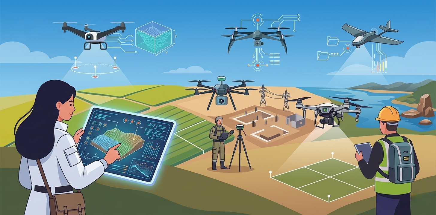
Drone Hardware
Multirotor drones — Ideal for small to medium survey areas, detailed inspections, and sites with obstacles. Slower and shorter range than fixed-wing, but highly manoeuvrable.
Fixed-wing drones — Better suited for large-area surveys (hundreds to thousands of hectares) due to their longer flight time and greater range. Less flexible for tight or complex terrain.
VTOL (Vertical Takeoff and Landing) drones — Combine the flexibility of multirotor launch and landing with the efficiency of fixed-wing cruise flight, making them increasingly popular for large-scale surveys.
Sensors and Payloads
- RGB cameras — Standard for construction, real estate, and general mapping applications
- Multispectral cameras — Essential for agriculture mapping, vegetation health analysis, and NDVI
- Thermal cameras — Used for building envelope inspections, solar panel surveys, and identifying heat anomalies
- LiDAR scanners — Generate dense, highly accurate 3D point clouds; particularly valuable for terrain mapping under vegetation canopy and precision engineering surveys
- RTK/PPK GPS — Enables centimetre-level positioning accuracy without ground control points
Processing Software
- Pix4D — Industry standard for photogrammetry processing; strong agriculture and construction modules
- DJI Terra — Optimised for DJI hardware; fast and accessible for operators working with DJI drone ecosystems
- Agisoft Metashape — Flexible, powerful photogrammetry platform popular for research and precision applications
- DroneDeploy — Cloud-based processing with strong project management and client reporting features
- QGIS / ArcGIS — GIS platforms for advanced spatial analysis and integration with planning workflows
Benefits of Drone for Mapping and Surveying
Speed
A drone can survey 100 hectares in a single flight lasting under an hour. The same area with traditional ground survey methods could take days. Processed deliverables are available within hours of data capture, enabling faster decision-making across all applications.
Cost Efficiency
Drone surveys consistently deliver cost savings of 40–60% compared to conventional methods, primarily through reduced labour requirements, faster turnaround, and elimination of expensive manned aerial surveys. For large-scale projects like the SVAMITVA scheme, these savings multiply dramatically at national scale.
Accuracy
Modern drone mapping systems achieve horizontal accuracy of 1–3 cm with RTK GPS — sufficient for legal surveys, engineering design, and precision agriculture applications. This level of accuracy was previously achievable only with expensive terrestrial laser scanners or manned aerial LiDAR surveys.
Safety
Many survey environments are inherently dangerous — steep slopes, active construction sites, mining operations, post-disaster zones, or infrastructure like power lines and bridges. Drones eliminate the need to put surveyors in harm's way while actually delivering richer, more detailed data than manual inspection methods.
Repeat Surveys and Change Detection
One of the most powerful applications of drone mapping is the ability to conduct frequent, consistent repeat surveys of the same area. Comparing orthomosaic maps or 3D models from different dates reveals changes — construction progress, crop growth stages, erosion patterns, or infrastructure degradation — with precision and clarity that single-visit surveys cannot provide.
This same principle underpins crop health monitoring and disease and pest detection in agriculture — where sequential drone maps reveal the spread of infection or the response to treatment over time.
Drone Mapping Regulations in India
Operating a drone for mapping and surveying commercially in India requires compliance with DGCA's Drone Rules 2021. Key requirements include:
- A Unique Identification Number (UIN) for drones above 250 grams
- A valid Remote Pilot Certificate (RPC) from a DGCA-approved RPTO for drones in the Small category and above
- Compliance with airspace zone restrictions (green, yellow, and red zones) via the Digital Sky Platform
- For surveys near airports, military areas, or international borders, additional permissions from relevant authorities
Survey-grade mapping drones — particularly those with RTK GPS and LiDAR payloads — typically fall in the Small category (2–25 kg) and require full DGCA certification. DGCA-approved drone pilot training programmes equip operators with the regulatory knowledge, flight skills, and safety protocols needed to conduct commercial mapping operations legally and professionally.
The Future of Drone for Mapping and Surveying
The next generation of drone for mapping and surveying technology will be defined by:
- AI-powered automated analysis — machine learning models that automatically classify features in aerial imagery (roads, buildings, crop types, infrastructure defects) without manual GIS interpretation
- Real-time processing — edge computing on the drone itself enabling instant deliverable generation during flight
- Swarm surveys — coordinated multi-drone flights dramatically reducing survey time over large areas
- Integration with BIM and digital twins — drone survey data feeding directly into building information models and live digital replicas of infrastructure and cities
- 5G connectivity — enabling real-time data streaming from drone to ground station and seamless integration with cloud-based project management platforms
India's drone mapping market is on a strong growth trajectory, supported by government programmes, expanding commercial demand, and a rapidly professionalising pilot and data analyst workforce.
Final Thoughts
Drone for mapping and surveying is one of the most mature, proven, and immediately valuable applications of UAV technology available today. Across agriculture, construction, land administration, mining, environmental monitoring, and disaster response, drone mapping is delivering faster insights, better data quality, and meaningful cost savings compared to every alternative.
For organisations looking to integrate drone mapping into their operations, the path is straightforward: identify the application, select the right hardware and sensor combination, ensure regulatory compliance through certified training, and partner with a drone service provider that can deliver end-to-end mission planning, execution, and data processing.