Drones in land surveying are transforming one of the most labour-intensive and time-consuming professional disciplines in India's infrastructure, construction, and agricultural sectors. What once required teams of surveyors spending days walking terrain with GPS receivers and total stations can now be accomplished by a single certified drone pilot in a few hours, with processed deliverables ready the same day. Academic studies confirm that UAV photogrammetry achieves centimetre-level accuracy when flights use RTK or PPK GNSS correction and well-distributed checkpoints, and field results consistently match this in real-world project environments. For India's rapidly expanding infrastructure pipeline and precision agriculture sector, the case for drone-based surveying has never been stronger.
1. What Are Drones in Land Surveying and How Do They Work?
Drones in land surveying are unmanned aerial vehicles equipped with high-resolution cameras, LiDAR scanners, multispectral sensors, and RTK/PPK GPS systems that capture geospatial data from above a survey area. Unlike ground-based surveying where data is collected point by point using total stations or GNSS receivers, drone surveys capture thousands of data points simultaneously in a single continuous flight pass.
Core hardware on a survey-grade drone typically includes:
- High-resolution RGB cameras for photogrammetry
- LiDAR scanners for dense, vegetation-penetrating point clouds
- Multispectral sensors for vegetation and soil analysis
- RTK/PPK GNSS systems for centimetre-level positional accuracy
The underlying technology is photogrammetry, a process where the drone captures hundreds of overlapping images from different angles, each tagged with precise coordinates from the onboard GNSS receiver. Photogrammetry software then stitches these images into georeferenced 2D orthomosaics and 3D point clouds, from which elevation models, contour lines, volumetric calculations, and cadastral maps are derived. Where higher accuracy or vegetation penetration is required, LiDAR sensors replace cameras, shooting millions of laser pulses that bounce off ground surfaces and return precise distance measurements regardless of plant cover above.
2. Why Are Drones in Land Surveying Replacing Traditional Methods?
Drones in land surveying are replacing traditional methods because they reduce field time by up to 45% and cut data collection costs by up to 50% compared to ground-based surveying. The operational advantages are compelling across every dimension of surveying practice.
Comparison Point | Traditional Ground Survey | Drone Survey |
Team size (50-hectare site) | 4–6 surveyors | 1 certified pilot |
Time to complete | 2–3 full days | Under 3 hours |
Deliverable turnaround | Days to weeks | Same day |
Field time reduction | Baseline | Up to 45% less |
Data collection cost | Baseline | Up to 50% less |
Airport drainage case study (2,200 acres) | Weeks of fieldwork | 1.5 cm horizontal / 2.5 cm vertical accuracy achieved rapidly |
Beyond speed, drones provide access to terrain that is genuinely dangerous or impractical for ground-based teams.
- Active construction zones — surveyed without exposing crews to moving equipment
- Steep slopes and unstable ground — mapped without risking falls or terrain hazards
- Post-disaster areas — assessed without sending people into unsafe structures
- Dense vegetation — captured from above instead of requiring manual clearing
This safety benefit is increasingly valued by project owners who carry liability exposure for field team safety incidents.
3. What Accuracy Can You Expect from Drones in Land Surveying?
Drones in land surveying consistently achieve sub-5 cm accuracy with disciplined workflows, and centimetre-level precision with RTK or PPK GNSS correction.
Survey Type / Study | Horizontal Accuracy | Vertical Accuracy | Notes |
Academic UAV photogrammetry benchmark | ~2–3 cm | ~3–6 cm | With RTK/PPK + well-placed ground control points |
1,000-acre pipeline monitoring survey | 2.3 cm | — | Field-documented result |
3,000-acre project | 1.5 cm (absolute) | — | Field-documented result |
20-hectare gravel pit stockpile study | — | 0.24 m³ difference vs. terrestrial laser scanner | Field time cut from a full day to ~1 hour |
It is important to understand that this accuracy is not automatic. It depends on:
- Ground control point placement
Disciplined workflow and proper validation against independent checkpoints are what convert raw drone data into survey-grade deliverables that engineers and planners can rely on.
4. The Step-by-Step Drone Land Survey Workflow
Understanding how drones in land surveying work in practice helps survey teams and clients know what to expect from a drone survey engagement.
Step | Stage | What Happens |
1 | Define the survey area and objectives | Set geographic extent, required accuracy, deliverable types (orthomosaic, DTM, DSM, point cloud, volumetric report), and intended downstream use |
2 | Plan the flight path | Program altitude, 70–80% image overlap in both directions, geofencing around restricted airspace, and full-area coverage — executed autonomously |
3 | Place ground control points (GCPs) | Distribute physical markers at known GPS coordinates; RTK-equipped drones need fewer GCPs due to real-time GNSS corrections |
4 | Execute the drone flight and capture data | Autonomous capture of overlapping images or LiDAR returns while the pilot monitors from the ground control station |
5 | Process the raw data | Photogrammetry software (Pix4D, Agisoft Metashape, DJI Terra) builds orthomosaics, point clouds, and elevation models; LiDAR data processed on specialist platforms |
6 | Validate accuracy with checkpoints | Compare drone-derived coordinates against ground-truth checkpoints to calculate RMSE and confirm accuracy requirements are met |
7 | Generate deliverables and integrate with workflows | Export orthomosaics, DTMs, DSMs, point clouds, contour maps, and volumetric reports in CAD/GIS/BIM-compatible formats |
5. The 5 Key Applications of Drones in Land Surveying
5.1. Topographic Surveys for Construction and Infrastructure
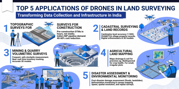
Topographic surveys are the most common application of drones in land surveying for India's construction and infrastructure sectors. Pre-construction DTMs and DSMs that would previously take survey teams a week to produce are now completed in hours, fed directly into civil engineering design software for cut-and-fill calculations, drainage planning, and foundation design.
- India's National Infrastructure Pipeline projects over Rs 111 lakh crore of infrastructure investment
- This is generating enormous demand for fast, accurate topographic survey data across road, rail, urban, and industrial projects
- Drone surveys reduce the cost of topographic data collection by 40 to 60% while delivering equal or superior accuracy
5.2. Cadastral Surveying and Land Records
Cadastral surveying — the mapping of property boundaries and land ownership records — is one of the most socially impactful applications of drones in land surveying in India. The government's SVAMITVA scheme has already completed cadastral drone surveys across 3.29 lakh villages, creating property records for rural communities for the first time in India's history.
- Produce 1:500 scale outputs meeting centimetre-level accuracy requirements
- Reduce data collection and processing time by up to 10 times compared to traditional methods
- Enable small teams to cover large areas using a single remote controller managing multiple drones simultaneously
- Deliverables include digital orthomosaic maps, digital surface models, and 3D reality models that are far more visually useful for stakeholders than traditional vector maps alone
5.3. Mining and Quarry Volumetric Surveys
Mining operations rely on frequent, accurate volumetric surveys of stockpiles, pit progress, and waste dumps for inventory management, financial reporting, and environmental compliance. Traditional ground-based stockpile measurement is slow, hazardous for surveyors working around active mining equipment, and infrequent enough that significant inventory discrepancies can accumulate between surveys.
Drone surveys of mining sites produce 3D stockpile models with documented volumetric accuracy that compares directly with terrestrial laser scanner measurements, while reducing survey time from a full working day to approximately one hour. The ability to repeat surveys frequently at low marginal cost transforms inventory tracking from a periodic exercise into a near-real-time management tool.
5.4. Agricultural Land Mapping
Agricultural land mapping is an application of drones in land surveying that directly supports precision agriculture services across India's farming regions. Drone-generated elevation models reveal drainage patterns, identify waterlogging zones, and map soil variability across farm plots, providing the spatial foundation for variable-rate input management programmes.
When combined with crop health monitoring using multispectral sensors, drone land surveys provide farmers with a comprehensive spatial understanding of their fields that supports smarter decisions about irrigation, fertiliser placement, and crop rotation. In India's fragmented farming landscape where 89.4% of farms are under two hectares, drone surveys that can rapidly and affordably map small, irregular plots are particularly valuable.
5.5. Disaster Assessment and Environmental Monitoring
Post-disaster damage assessment is a time-critical application where drones in land surveying deliver outcomes that no other method can match for speed. After floods, earthquakes, or landslides, drone surveys produce accurate aerial maps of affected areas within hours, providing disaster response teams with the geospatial intelligence needed to plan rescue operations, assess infrastructure damage, and prioritise relief logistics.
All of these benefit from the same combination of speed, spatial resolution, and repeat survey capability that makes drones valuable in engineering survey contexts. For organisations involved in seed spreading and reforestation programmes, drone surveys provide the pre-planting terrain analysis and post-planting progress monitoring that maximises reforestation success rates.
6. What Sensors and Platforms Are Used for Drone Land Surveying?
Sensor Type | Best Used For | Key Characteristics |
RGB Cameras with RTK GPS | Most commercial topographic, cadastral, and construction surveys | Cost-effective, straightforward to process, centimetre-level accuracy with RTK GPS; modern platforms use mechanical shutters to eliminate blur |
LiDAR Scanners | Engineering-grade infrastructure survey, forestry, vegetation-covered terrain | Highest accuracy, penetrates vegetation canopy, directly measures 3D coordinates rather than deriving them, produces very high point density |
Multispectral Sensors | Agricultural and environmental monitoring | Captures near-infrared and other wavelengths beyond human vision to reveal vegetation health, soil moisture, and land cover; bridges land survey with precision agriculture drone services |
7. What Regulations Apply to Drones in Land Surveying in India?
Commercial drone land surveying in India is regulated by the DGCA under the Drone Rules 2021.
- All drones above 250 grams used for commercial survey operations must be registered with a Unique Identification Number on the Digital Sky Platform
- Operating pilots must hold a valid Remote Pilot Certificate obtained from a DGCA-approved training programme
- Survey operations near airports, military facilities, or international borders require additional airspace permissions from relevant ATC authorities through the Digital Sky Platform
- Cadastral surveys conducted in support of government land record programmes may require additional coordination with state revenue authorities
- Survey companies and DaaS providers should verify full compliance status before mobilising to site on any commercial project
Final Thoughts
Drones in land surveying have moved from an emerging technology to a commercially proven, operationally standard tool across construction, infrastructure, mining, agriculture, and disaster management in India. The combination of centimetre-level accuracy, dramatically reduced field time, improved safety, and rich multi-purpose data output makes drone surveys the rational choice for the vast majority of survey applications that do not require boundary peg-level control network precision.
Whether you are a construction project manager looking to improve survey efficiency, an agricultural operator seeking spatial data to underpin precision farming decisions, or a survey professional looking to build drone capability through a DGCA-certified training programme, the tools and regulatory framework to make drone surveying work for you are fully in place in India in 2026.